
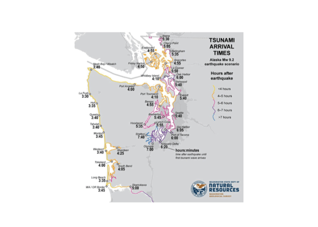
A Washington Department of Natural Resources map showing tsunami arrival times has attracted attention because it indicates that a tsunami generated by a magnitude 9.2 Alaska earthquake could reach Long Beach approximately three hours and 35 minutes after the earthquake.
For Pacific County, the map estimates the first wave would arrive at:
Long Beach: 3 hours, 35 minutes
Washington–Oregon border: 3 hours, 45 minutes
Tokeland: 4 hours
South Bend: 4 hours, 5 minutes

Those estimates apply only to the specific distant Alaska earthquake scenario modeled by DNR. They should not be interpreted as the amount of time residents would have following a major earthquake off the Washington coast.
A Cascadia tsunami could arrive within 15 minutes
Pacific County’s most dangerous tsunami threat comes from the Cascadia Subduction Zone, located just offshore. Following a magnitude 9 Cascadia earthquake, Washington’s official evacuation maps estimate that the first tsunami wave could reach the ocean side of Long Beach and Seaview approximately 15 minutes after the earthquake begins.

Because the earthquake itself could produce several minutes of intense shaking, residents might have only about 10 minutes—or less—after the shaking stops to reach safety. Arrival times may be longer along portions of Willapa Bay, but nobody should delay evacuation based on a generalized estimate.
The natural warning signs are:
Strong or prolonged earthquake shaking
A sudden rise or withdrawal of ocean water
A loud roar coming from the ocean
If any of these occur, immediately move inland, to high ground or to an approved vertical-evacuation structure. Do not wait for a siren, cellphone alert or instructions from officials. Washington Emergency Management emphasizes that ground shaking is the primary warning for a locally generated tsunami.
Evacuate on foot when possible
Roads could be blocked by fallen trees, damaged bridges, liquefaction, debris and abandoned vehicles. Traffic congestion could also consume the few minutes available. Official walk-time maps therefore plan primarily for pedestrian evacuation.
Residents should identify the safest route from their home, workplace and frequently visited locations. They should then walk the route in advance and determine whether everyone in the household—including older adults, children, people with disabilities and pets—can reach safety within the available time.
The Long Beach Peninsula’s flat terrain and limited nearby high ground make preparation and vertical-evacuation facilities especially important. Some locations may be too far from natural high ground to reach safety at a normal walking pace.
The first wave may not be the largest
Reaching an evacuation area does not mean the emergency is over. A tsunami consists of multiple waves, and dangerous flooding and currents can continue for many hours. People should remain outside the inundation zone until authorities issue an official all-clear.
The Alaska map illustrates that distant tsunamis may provide Pacific County with several hours of warning. Cascadia presents a much different reality: the earthquake itself may be the only reliable warning, and every minute will matter.
Residents can review community evacuation maps through the Pacific County Emergency Management Agency and detailed pedestrian walk-time maps through Washington Emergency Management. Washington DNR also provides statewide hazard information through its tsunami information page.

