
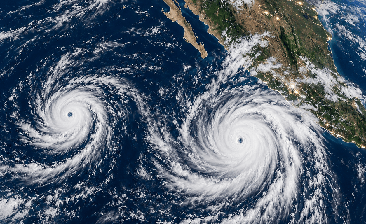
Hurricane Polo’s explosive development off Mexico’s Pacific coast is a dramatic example of how favorable ocean and atmospheric conditions can transform a tropical storm into an exceptionally powerful hurricane.
Polo reached Category 5 strength on September 22, with sustained winds near 165 mph. Although the storm’s center was forecast to remain offshore, its slow movement placed parts of southwestern Mexico at risk from torrential rainfall, flash flooding, landslides, destructive surf and coastal erosion. Guerrero and Michoacán faced the greatest danger, with significant rain also expected in Oaxaca, Colima and Jalisco.
The storm weakened slightly to Category 4 early September 23, but it remained an extremely dangerous hurricane. A small change in its track could still produce substantially different conditions along Mexico’s mountainous Pacific coast, where heavy rain can become deadly even when a hurricane’s eye never reaches land.
How El Niño may have helped Polo
Hurricane Polo did not create El Niño, and no single storm can be blamed entirely on it. However, the developing El Niño has made parts of the eastern Pacific more favorable for powerful hurricanes.
During El Niño, unusually warm water spreads across the central and eastern tropical Pacific. Warmer water provides additional heat and moisture that thunderstorms can convert into hurricane energy. El Niño also tends to reduce the disruptive changes in wind speed and direction—known as vertical wind shear—over parts of the eastern Pacific.
NOAA says these conditions are generally associated with increased tropical-storm and hurricane activity in the eastern and central Pacific, while stronger wind shear often suppresses hurricanes in the Atlantic.
Polo’s rapid intensification therefore fits the kind of eastern Pacific hurricane activity that can become more likely during El Niño. But other factors—including the storm’s small inner core, atmospheric moisture and its precise path over exceptionally warm water—also affected its rapid growth.
An exceptionally strong El Niño is developing
NOAA declared an El Niño Advisory on September 10 and reported that the event was continuing to strengthen. Ocean temperatures in the eastern equatorial Pacific were more than 3°C above average in some areas, while unusually warm water extended deep below the surface.
NOAA estimated a greater than 90% chance that El Niño would become very strong during the fall and winter of 2026–27. It also placed the probability of a potentially historic event—stronger than previous El Niños in the modern record—at 75% during October through December.
That does not guarantee a particular storm, flood or drought. El Niño changes the odds by influencing ocean temperatures, tropical rainfall and the position of the Pacific jet stream. Shorter-term weather patterns still determine where individual storms ultimately travel.
Could Polo reach the United States?
Polo itself is not expected to strike Washington, Oregon or California as a hurricane. Pacific hurricanes usually weaken rapidly if they move north because they encounter colder ocean water, stronger wind shear and less favorable atmospheric conditions.
Moisture from an eastern Pacific hurricane can occasionally travel north and become incorporated into another weather system. That can produce heavy rain in the Southwest or, less commonly, farther north. However, Polo’s interaction with another tropical system and its anticipated movement offshore may limit how much of its moisture reaches the United States.
The larger West Coast concern is therefore not a direct hurricane strike. It is what the strengthening El Niño may mean for ocean levels, winter storms, rainfall, erosion and water supplies during the coming months.
What El Niño could mean for California
A strong El Niño commonly shifts the Pacific jet stream southward, increasing the chances of a wetter and stormier winter across California and the southern United States.
For California, possible effects include:
- More frequent or stronger Pacific storms
- Heavy rain and flash flooding
- Landslides in steep terrain and wildfire burn areas
- Larger waves and accelerated beach erosion
- Increased coastal flooding when storms coincide with high tides
- More rain instead of snow at some mountain elevations
El Niño does not guarantee a wet winter everywhere in California. Some previous events have failed to produce the anticipated rainfall because the location of the warmest water and the atmospheric response differed from expectations.
What it could mean for Oregon and Washington
The traditional El Niño pattern is different in the Pacific Northwest. Washington and Oregon often experience warmer-than-average winters, with a tendency toward below-average precipitation—particularly across northern portions of the region.
Possible consequences include:
- Reduced mountain snowpack
- Earlier spring snowmelt
- Lower summer streamflows
- Greater stress on salmon and cold-water habitat
- Increased drought and wildfire concerns during the following summer
- More winter precipitation falling as rain rather than snow
These are seasonal tendencies, not promises. Individual atmospheric rivers and windstorms can still cause severe flooding or damage during an otherwise relatively warm or dry El Niño winter. NOAA emphasizes that El Niño influences probabilities rather than determining the weather in every community.
A rising coastal-flooding concern
El Niño can also raise sea levels temporarily along the West Coast. Weakened tropical trade winds generate Kelvin waves that move eastward along the equator and then north along the coasts of the Americas. These waves deepen the layer of warm water and can elevate coastal water levels for months.
When those higher background water levels combine with king tides, large waves or storm surge, flooding can reach farther inland. NOAA warns that El Niño and long-term sea-level rise can produce a “double whammy” for coastal communities.
For low-lying communities along Washington’s Long Beach Peninsula, the most important risks to monitor are high tides, powerful surf, shoreline erosion, heavy rain, drainage problems and winter windstorms—not a tropical hurricane arriving intact from Mexico.
Polo may be an early warning
Hurricane Polo is first and foremost an immediate emergency for Mexico. Its extreme strength, even while remaining offshore, demonstrates how rapidly a storm can become dangerous over unusually warm Pacific water.
For the American West Coast, Polo should be viewed as an early warning from the larger Pacific system. California may face increased risks from heavy winter rain, erosion and coastal flooding. Washington and Oregon may lean warmer and drier overall, potentially reducing snowpack, while still remaining vulnerable to occasional powerful storms and high-water events.
El Niño does not write the forecast by itself—but this developing event is strong enough that coastal communities should begin preparing now rather than waiting for the first major winter storm.

